|
|
|||||||||||||||||
| Point ID: 8470 | Downloads | Plots | Site Data | Code: 10290 |
|
|
|||||||||||||||||
| Download | |
|---|---|
| Site Descriptor Information | Site Time Series Data |
| Link to all available data | |
| View: | Time Series | All |
| Units: | mm |
| Statistic | Jan | Feb | Mar | Apr | May | Jun | Jul | Aug | Sep | Oct | Nov | Dec | Annual |
|---|---|---|---|---|---|---|---|---|---|---|---|---|---|
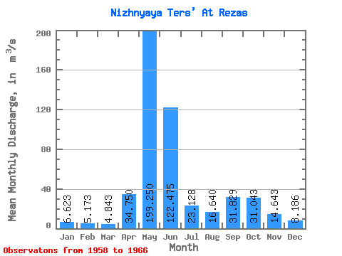
| Mean | 6.62 | 5.17 | 4.84 | 34.75 | 199.25 | 122.47 | 23.13 | 16.64 | 31.83 | 31.04 | 14.64 | 8.19 | 40.62 |
| Standard Deviation | 3.07 | 0.92 | 1.56 | 19.00 | 40.97 | 67.29 | 8.63 | 7.37 | 17.73 | 10.65 | 4.21 | 1.02 | 4.23 |
| Min | 4.94 | 4.07 | 3.08 | 16.20 | 147.00 | 44.00 | 9.22 | 7.70 | 13.60 | 21.00 | 10.10 | 6.95 | 33.84 |
| Max | 14.10 | 6.84 | 7.34 | 70.40 | 264.00 | 217.00 | 36.70 | 29.30 | 57.40 | 47.30 | 23.40 | 9.40 | 45.10 |
| Coefficient of Variation | 0.46 | 0.18 | 0.32 | 0.55 | 0.21 | 0.55 | 0.37 | 0.44 | 0.56 | 0.34 | 0.29 | 0.12 | 0.10 |
 Return to R-Arctic Net Home Page