|
|
|||||||||||||||||
| Point ID: 8223 | Downloads | Plots | Site Data | Code: 8265 |
|
|
|||||||||||||||||
| Download | |
|---|---|
| Site Descriptor Information | Site Time Series Data |
| Link to all available data | |
| View: | Time Series | All |
| Units: | mm |
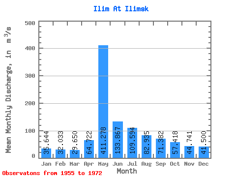
| Statistic | Jan | Feb | Mar | Apr | May | Jun | Jul | Aug | Sep | Oct | Nov | Dec | Annual |
|---|---|---|---|---|---|---|---|---|---|---|---|---|---|
| Mean | 35.64 | 32.03 | 29.65 | 64.72 | 411.28 | 133.87 | 109.59 | 82.94 | 71.38 | 57.42 | 44.74 | 41.50 | 93.91 |
| Standard Deviation | 6.24 | 5.95 | 5.32 | 52.11 | 110.33 | 51.27 | 44.65 | 20.06 | 17.85 | 14.82 | 8.70 | 7.24 | 14.32 |
| Min | 26.10 | 23.30 | 20.10 | 30.10 | 136.00 | 77.50 | 48.50 | 50.20 | 43.80 | 32.40 | 31.00 | 28.10 | 72.40 |
| Max | 46.70 | 45.00 | 37.20 | 220.00 | 581.00 | 214.00 | 221.00 | 124.00 | 103.00 | 82.60 | 56.60 | 52.00 | 112.33 |
| Coefficient of Variation | 0.17 | 0.19 | 0.18 | 0.81 | 0.27 | 0.38 | 0.41 | 0.24 | 0.25 | 0.26 | 0.19 | 0.17 | 0.15 |
 Return to R-Arctic Net Home Page