|
|
|||||||||||||||||
| Point ID: 7709 | Downloads | Plots | Site Data | Code: 15565447 |
|
|
|||||||||||||||||
| Download | |
|---|---|
| Site Descriptor Information | Site Time Series Data |
| Link to all available data | |
| View: | Time Series | All |
| Units: | mm |
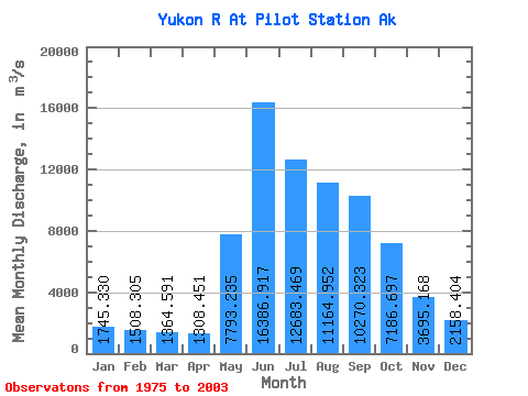
| Statistic | Jan | Feb | Mar | Apr | May | Jun | Jul | Aug | Sep | Oct | Nov | Dec | Annual |
|---|---|---|---|---|---|---|---|---|---|---|---|---|---|
| Mean | 1745.33 | 1508.31 | 1364.59 | 1308.45 | 7793.23 | 16386.92 | 12683.47 | 11164.95 | 10270.32 | 7186.70 | 3695.17 | 2158.40 | 6445.30 |
| Standard Deviation | 226.65 | 188.92 | 147.79 | 136.85 | 3039.27 | 3280.05 | 1819.29 | 1421.22 | 1563.02 | 1484.34 | 1035.36 | 377.52 | 561.18 |
| Min | 1415.84 | 1086.80 | 995.62 | 1088.22 | 2837.35 | 10318.66 | 8891.49 | 8919.81 | 7155.67 | 4830.85 | 2052.97 | 1415.84 | 4945.87 |
| Max | 2152.08 | 1850.79 | 1607.55 | 1557.43 | 14206.56 | 23916.41 | 15956.54 | 14605.83 | 13628.90 | 9511.63 | 5996.56 | 2685.57 | 7247.84 |
| Coefficient of Variation | 0.13 | 0.12 | 0.11 | 0.10 | 0.39 | 0.20 | 0.14 | 0.13 | 0.15 | 0.21 | 0.28 | 0.17 | 0.09 |
 Return to R-Arctic Net Home Page