|
|
|||||||||||||||||
| Point ID: 7423 | Downloads | Plots | Site Data | Code: 70284 |
|
|
|||||||||||||||||
| Download | |
|---|---|
| Site Descriptor Information | Site Time Series Data |
| Link to all available data | |
| View: | Time Series | All |
| Units: | mm |
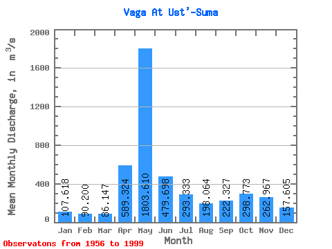
| Statistic | Jan | Feb | Mar | Apr | May | Jun | Jul | Aug | Sep | Oct | Nov | Dec | Annual |
|---|---|---|---|---|---|---|---|---|---|---|---|---|---|
| Mean | 107.62 | 90.20 | 86.15 | 589.32 | 1803.61 | 479.70 | 293.33 | 198.06 | 222.33 | 298.77 | 262.97 | 157.60 | 384.28 |
| Standard Deviation | 30.27 | 21.15 | 23.96 | 464.49 | 677.68 | 216.64 | 189.44 | 132.64 | 149.30 | 163.81 | 135.33 | 68.27 | 77.27 |
| Min | 58.90 | 58.60 | 65.00 | 83.30 | 670.00 | 150.00 | 86.30 | 77.70 | 79.50 | 111.00 | 96.70 | 82.30 | 241.18 |
| Max | 196.00 | 136.00 | 203.00 | 1850.00 | 3320.00 | 1120.00 | 825.00 | 755.00 | 677.00 | 866.00 | 622.00 | 415.00 | 536.87 |
| Coefficient of Variation | 0.28 | 0.23 | 0.28 | 0.79 | 0.38 | 0.45 | 0.65 | 0.67 | 0.67 | 0.55 | 0.52 | 0.43 | 0.20 |
 Return to R-Arctic Net Home Page