|
|
|||||||||||||||||
| Point ID: 7388 | Downloads | Plots | Site Data | Code: 70184 |
|
|
|||||||||||||||||
| Download | |
|---|---|
| Site Descriptor Information | Site Time Series Data |
| Link to all available data | |
| View: | Time Series | All |
| Units: | mm |
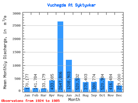
| Statistic | Jan | Feb | Mar | Apr | May | Jun | Jul | Aug | Sep | Oct | Nov | Dec | Annual |
|---|---|---|---|---|---|---|---|---|---|---|---|---|---|
| Mean | 170.18 | 141.78 | 133.18 | 433.08 | 2647.81 | 1208.90 | 520.53 | 370.40 | 380.77 | 520.98 | 416.48 | 239.00 | 598.59 |
| Standard Deviation | 45.90 | 33.59 | 30.09 | 365.64 | 721.91 | 551.40 | 240.53 | 203.62 | 214.55 | 218.77 | 177.31 | 71.73 | 109.41 |
| Min | 83.80 | 73.70 | 68.10 | 94.30 | 944.00 | 345.00 | 180.00 | 150.00 | 150.00 | 179.00 | 159.00 | 134.00 | 299.75 |
| Max | 348.00 | 249.00 | 225.00 | 1750.00 | 4390.00 | 2750.00 | 1330.00 | 1220.00 | 1310.00 | 1160.00 | 955.00 | 493.00 | 842.33 |
| Coefficient of Variation | 0.27 | 0.24 | 0.23 | 0.84 | 0.27 | 0.46 | 0.46 | 0.55 | 0.56 | 0.42 | 0.43 | 0.30 | 0.18 |
 Return to R-Arctic Net Home Page