|
|
|||||||||||||||||
| Point ID: 7124 | Downloads | Plots | Site Data | Code: 11588 |
|
|
|||||||||||||||||
| Download | |
|---|---|
| Site Descriptor Information | Site Time Series Data |
| Link to all available data | |
| View: | Time Series | All |
| Units: | mm |
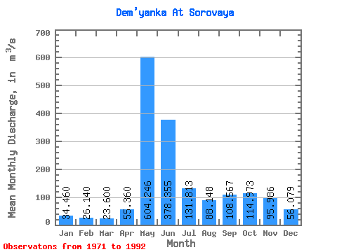
| Statistic | Jan | Feb | Mar | Apr | May | Jun | Jul | Aug | Sep | Oct | Nov | Dec | Annual |
|---|---|---|---|---|---|---|---|---|---|---|---|---|---|
| Mean | 34.46 | 26.14 | 23.60 | 55.36 | 604.25 | 378.36 | 131.81 | 88.15 | 108.57 | 114.97 | 95.99 | 56.08 | 166.87 |
| Standard Deviation | 14.65 | 6.93 | 4.82 | 49.59 | 348.22 | 310.17 | 155.38 | 103.18 | 75.97 | 84.76 | 68.94 | 31.64 | 67.69 |
| Min | 16.90 | 14.80 | 14.70 | 20.20 | 0.32 | 0.26 | 0.18 | 0.12 | 24.30 | 23.60 | 22.30 | 19.50 | 77.53 |
| Max | 64.20 | 37.30 | 30.70 | 222.00 | 1150.00 | 1280.00 | 639.00 | 424.00 | 226.00 | 270.00 | 240.00 | 112.00 | 351.59 |
| Coefficient of Variation | 0.42 | 0.27 | 0.20 | 0.90 | 0.58 | 0.82 | 1.18 | 1.17 | 0.70 | 0.74 | 0.72 | 0.56 | 0.41 |
 Return to R-Arctic Net Home Page