|
|
|||||||||||||||||
| Point ID: 6970 | Downloads | Plots | Site Data | Code: 11117 |
|
|
|||||||||||||||||
| Download | |
|---|---|
| Site Descriptor Information | Site Time Series Data |
| Link to all available data | |
| View: | Time Series | All |
| Units: | mm |
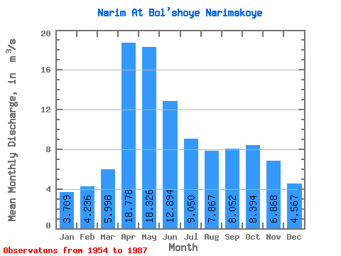
| Statistic | Jan | Feb | Mar | Apr | May | Jun | Jul | Aug | Sep | Oct | Nov | Dec | Annual |
|---|---|---|---|---|---|---|---|---|---|---|---|---|---|
| Mean | 3.71 | 4.24 | 6.00 | 18.78 | 18.33 | 12.89 | 9.05 | 7.87 | 8.05 | 8.39 | 6.87 | 4.57 | 8.97 |
| Standard Deviation | 1.23 | 1.65 | 1.95 | 6.54 | 9.23 | 6.54 | 4.44 | 3.40 | 2.57 | 2.27 | 1.78 | 1.48 | 2.90 |
| Min | 1.83 | 1.71 | 3.19 | 7.96 | 5.81 | 2.63 | 2.09 | 2.56 | 3.51 | 5.43 | 4.13 | 2.30 | 4.61 |
| Max | 6.58 | 7.97 | 12.10 | 33.40 | 55.10 | 29.70 | 19.70 | 16.40 | 13.40 | 15.10 | 11.10 | 7.42 | 15.75 |
| Coefficient of Variation | 0.33 | 0.39 | 0.33 | 0.35 | 0.50 | 0.51 | 0.49 | 0.43 | 0.32 | 0.27 | 0.26 | 0.32 | 0.32 |
 Return to R-Arctic Net Home Page