|
|
|||||||||||||||||
| Point ID: 6658 | Downloads | Plots | Site Data | Code: 10006 |
|
|
|||||||||||||||||
| Download | |
|---|---|
| Site Descriptor Information | Site Time Series Data |
| Link to all available data | |
| View: | Time Series | All |
| Units: | mm |
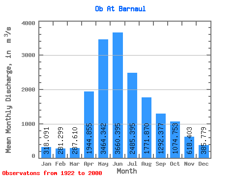
| Statistic | Jan | Feb | Mar | Apr | May | Jun | Jul | Aug | Sep | Oct | Nov | Dec | Annual |
|---|---|---|---|---|---|---|---|---|---|---|---|---|---|
| Mean | 318.09 | 281.30 | 287.61 | 1944.86 | 3464.34 | 3660.39 | 2485.39 | 1771.87 | 1292.38 | 1074.75 | 618.40 | 385.78 | 1466.99 |
| Standard Deviation | 56.46 | 52.53 | 68.95 | 689.11 | 840.49 | 1108.05 | 778.55 | 535.46 | 387.73 | 321.35 | 210.18 | 94.07 | 262.92 |
| Min | 199.00 | 198.00 | 191.00 | 464.00 | 1640.00 | 1630.00 | 1220.00 | 945.00 | 666.00 | 501.00 | 335.00 | 238.00 | 1021.83 |
| Max | 447.00 | 428.00 | 590.00 | 3920.00 | 6630.00 | 7080.00 | 5730.00 | 3900.00 | 2520.00 | 2250.00 | 1310.00 | 642.00 | 2297.33 |
| Coefficient of Variation | 0.18 | 0.19 | 0.24 | 0.35 | 0.24 | 0.30 | 0.31 | 0.30 | 0.30 | 0.30 | 0.34 | 0.24 | 0.18 |
 Return to R-Arctic Net Home Page