|
|
|||||||||||||||||
| Point ID: 6576 | Downloads | Plots | Site Data | Code: 9252 |
|
|
|||||||||||||||||
| Download | |
|---|---|
| Site Descriptor Information | Site Time Series Data |
| Link to all available data | |
| View: | Time Series | All |
| Units: | mm |
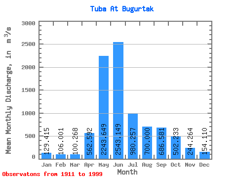
| Statistic | Jan | Feb | Mar | Apr | May | Jun | Jul | Aug | Sep | Oct | Nov | Dec | Annual |
|---|---|---|---|---|---|---|---|---|---|---|---|---|---|
| Mean | 129.41 | 106.00 | 100.27 | 562.59 | 2243.65 | 2543.15 | 980.26 | 700.00 | 686.58 | 502.23 | 244.26 | 154.11 | 746.37 |
| Standard Deviation | 21.30 | 16.86 | 17.98 | 293.78 | 527.85 | 840.54 | 311.27 | 258.94 | 285.76 | 179.47 | 76.12 | 30.36 | 110.05 |
| Min | 83.70 | 69.40 | 62.00 | 140.00 | 1100.00 | 853.00 | 488.00 | 320.00 | 254.00 | 228.00 | 139.00 | 82.10 | 534.57 |
| Max | 167.00 | 139.00 | 160.00 | 1840.00 | 4000.00 | 5620.00 | 1670.00 | 1430.00 | 1730.00 | 1300.00 | 547.00 | 222.00 | 1048.08 |
| Coefficient of Variation | 0.17 | 0.16 | 0.18 | 0.52 | 0.23 | 0.33 | 0.32 | 0.37 | 0.42 | 0.36 | 0.31 | 0.20 | 0.15 |
 Return to R-Arctic Net Home Page