|
|
|||||||||||||||||
| Point ID: 6521 | Downloads | Plots | Site Data | Code: 8356 |
|
|
|||||||||||||||||
| Download | |
|---|---|
| Site Descriptor Information | Site Time Series Data |
| Link to all available data | |
| View: | Time Series | All |
| Units: | mm |
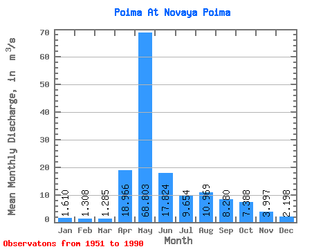
| Statistic | Jan | Feb | Mar | Apr | May | Jun | Jul | Aug | Sep | Oct | Nov | Dec | Annual |
|---|---|---|---|---|---|---|---|---|---|---|---|---|---|
| Mean | 1.61 | 1.31 | 1.28 | 18.97 | 68.80 | 17.82 | 9.65 | 10.97 | 8.28 | 7.39 | 4.00 | 2.20 | 12.71 |
| Standard Deviation | 0.64 | 0.56 | 0.59 | 17.38 | 29.91 | 8.70 | 4.51 | 12.19 | 8.15 | 4.29 | 2.08 | 0.90 | 4.05 |
| Min | 0.60 | 0.37 | 0.29 | 1.37 | 18.20 | 6.37 | 4.16 | 2.28 | 1.72 | 2.47 | 1.64 | 0.89 | 4.85 |
| Max | 2.90 | 2.85 | 2.68 | 63.90 | 154.00 | 40.00 | 23.00 | 53.40 | 53.80 | 21.60 | 11.10 | 4.16 | 22.11 |
| Coefficient of Variation | 0.40 | 0.43 | 0.46 | 0.92 | 0.43 | 0.49 | 0.47 | 1.11 | 0.98 | 0.58 | 0.52 | 0.41 | 0.32 |
 Return to R-Arctic Net Home Page