|
|
|||||||||||||||||
| Point ID: 6468 | Downloads | Plots | Site Data | Code: 8161 |
|
|
|||||||||||||||||
| Download | |
|---|---|
| Site Descriptor Information | Site Time Series Data |
| Link to all available data | |
| View: | Time Series | All |
| Units: | mm |
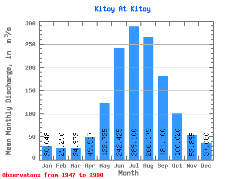
| Statistic | Jan | Feb | Mar | Apr | May | Jun | Jul | Aug | Sep | Oct | Nov | Dec | Annual |
|---|---|---|---|---|---|---|---|---|---|---|---|---|---|
| Mean | 30.05 | 25.29 | 24.97 | 49.52 | 122.72 | 242.43 | 289.10 | 266.18 | 181.10 | 100.02 | 52.90 | 37.08 | 118.45 |
| Standard Deviation | 6.54 | 5.86 | 4.97 | 11.92 | 31.27 | 58.40 | 102.92 | 75.29 | 50.69 | 22.77 | 10.50 | 7.83 | 20.60 |
| Min | 17.40 | 14.70 | 15.30 | 30.60 | 55.30 | 145.00 | 167.00 | 161.00 | 102.00 | 61.80 | 33.60 | 21.70 | 81.69 |
| Max | 46.60 | 38.10 | 36.20 | 80.70 | 189.00 | 423.00 | 581.00 | 471.00 | 295.00 | 174.00 | 71.30 | 59.70 | 170.43 |
| Coefficient of Variation | 0.22 | 0.23 | 0.20 | 0.24 | 0.26 | 0.24 | 0.36 | 0.28 | 0.28 | 0.23 | 0.20 | 0.21 | 0.17 |
 Return to R-Arctic Net Home Page