|
|
|||||||||||||||||
| Point ID: 6453 | Downloads | Plots | Site Data | Other Close Sites | Code: 8013 |
|
|
|||||||||||||||||
| Download | |
|---|---|
| Site Descriptor Information | Site Time Series Data |
| Link to all available data | |
| View: | Time Series | All |
| Units: | mm |
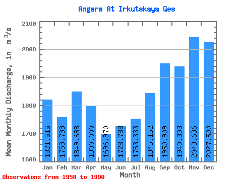
| Statistic | Jan | Feb | Mar | Apr | May | Jun | Jul | Aug | Sep | Oct | Nov | Dec | Annual |
|---|---|---|---|---|---|---|---|---|---|---|---|---|---|
| Mean | 1821.52 | 1758.79 | 1849.69 | 1800.00 | 1696.97 | 1728.79 | 1753.33 | 1845.15 | 1950.91 | 1940.30 | 2043.64 | 2027.50 | 1863.28 |
| Standard Deviation | 377.09 | 334.26 | 378.06 | 418.49 | 314.01 | 239.31 | 392.07 | 549.11 | 588.43 | 504.07 | 487.70 | 459.74 | 276.05 |
| Min | 1240.00 | 1200.00 | 1140.00 | 1100.00 | 1130.00 | 1310.00 | 1320.00 | 1320.00 | 1320.00 | 1320.00 | 1270.00 | 1260.00 | 1297.50 |
| Max | 2550.00 | 2680.00 | 2710.00 | 2620.00 | 2300.00 | 2170.00 | 3270.00 | 3460.00 | 3600.00 | 3000.00 | 2810.00 | 2750.00 | 2466.67 |
| Coefficient of Variation | 0.21 | 0.19 | 0.20 | 0.23 | 0.18 | 0.14 | 0.22 | 0.30 | 0.30 | 0.26 | 0.24 | 0.23 | 0.15 |
| Other Close Sites | ||||||
|---|---|---|---|---|---|---|
| PointID | Latitude | Longitude | Drainage Area | Source | Name | |
| 6454 | "Angara At Ostrov Yunost'" | 52.27 | 1019064 | SHI | 1717.00 | |
| 6463 | "Irkut At Irkutsk" | 52.28 | 1016017 | SHI | 2.00 | |
 Return to R-Arctic Net Home Page