|
|
|||||||||||||||||
| Point ID: 6423 | Downloads | Plots | Site Data | Code: 7088 |
|
|
|||||||||||||||||
| Download | |
|---|---|
| Site Descriptor Information | Site Time Series Data |
| Link to all available data | |
| View: | Time Series | All |
| Units: | mm |
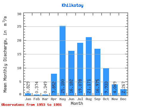
| Statistic | Jan | Feb | Mar | Apr | May | Jun | Jul | Aug | Sep | Oct | Nov | Dec | Annual |
|---|---|---|---|---|---|---|---|---|---|---|---|---|---|
| Mean | 0.83 | 0.37 | 0.35 | 7.85 | 25.18 | 16.18 | 19.08 | 21.17 | 16.98 | 9.93 | 4.05 | 2.27 | 10.88 |
| Standard Deviation | 0.73 | 0.49 | 0.55 | 6.37 | 11.61 | 10.00 | 12.44 | 12.96 | 7.24 | 3.06 | 1.65 | 1.07 | 3.12 |
| Min | 0.01 | 0.01 | 0.00 | 0.23 | 7.79 | 0.92 | 3.10 | 4.84 | 6.17 | 4.91 | 0.83 | 0.86 | 5.92 |
| Max | 3.17 | 1.81 | 2.31 | 26.20 | 48.20 | 52.40 | 64.40 | 59.50 | 43.40 | 18.40 | 7.46 | 5.60 | 20.00 |
| Coefficient of Variation | 0.89 | 1.30 | 1.56 | 0.81 | 0.46 | 0.62 | 0.65 | 0.61 | 0.43 | 0.31 | 0.41 | 0.47 | 0.29 |
 Return to R-Arctic Net Home Page