|
|
|||||||||||||||||
| Point ID: 6341 | Downloads | Plots | Site Data | Code: 3811 |
|
|
|||||||||||||||||
| Download | |
|---|---|
| Site Descriptor Information | Site Time Series Data |
| Link to all available data | |
| View: | Time Series | All |
| Units: | mm |
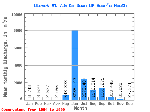
| Statistic | Jan | Feb | Mar | Apr | May | Jun | Jul | Aug | Sep | Oct | Nov | Dec | Annual |
|---|---|---|---|---|---|---|---|---|---|---|---|---|---|
| Mean | 8.74 | 3.63 | 2.54 | 2.10 | 548.33 | 8085.14 | 2373.40 | 1176.31 | 1369.27 | 393.45 | 83.02 | 27.27 | 1172.77 |
| Standard Deviation | 5.11 | 1.38 | 1.18 | 1.09 | 1138.92 | 2418.82 | 1252.97 | 760.44 | 817.16 | 223.86 | 26.59 | 11.52 | 329.02 |
| Min | 1.83 | 1.25 | 0.51 | 0.11 | 1.36 | 4690.00 | 599.00 | 117.00 | 92.50 | 44.60 | 21.80 | 7.08 | 644.99 |
| Max | 30.70 | 6.42 | 4.72 | 4.13 | 5510.00 | 15500.00 | 5550.00 | 3320.00 | 4360.00 | 984.00 | 146.00 | 63.90 | 1838.57 |
| Coefficient of Variation | 0.58 | 0.38 | 0.47 | 0.52 | 2.08 | 0.30 | 0.53 | 0.65 | 0.60 | 0.57 | 0.32 | 0.42 | 0.28 |
 Return to R-Arctic Net Home Page