|
|
|||||||||||||||||
| Point ID: 6308 | Downloads | Plots | Site Data | Code: 3518 |
|
|
|||||||||||||||||
| Download | |
|---|---|
| Site Descriptor Information | Site Time Series Data |
| Link to all available data | |
| View: | Time Series | All |
| Units: | mm |
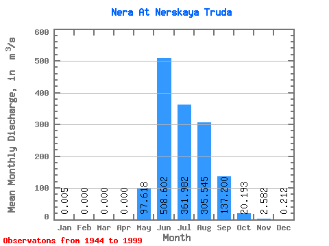
| Statistic | Jan | Feb | Mar | Apr | May | Jun | Jul | Aug | Sep | Oct | Nov | Dec | Annual |
|---|---|---|---|---|---|---|---|---|---|---|---|---|---|
| Mean | 0.01 | 0.00 | 0.00 | 0.00 | 97.62 | 508.60 | 361.98 | 305.55 | 137.20 | 20.19 | 2.58 | 0.21 | 119.50 |
| Standard Deviation | 0.02 | 0.00 | 0.00 | 0.00 | 103.36 | 233.26 | 163.20 | 135.36 | 80.76 | 8.69 | 1.57 | 0.34 | 33.10 |
| Min | 0.00 | 0.00 | 0.00 | 0.00 | 3.81 | 93.70 | 127.00 | 67.50 | 36.50 | 5.52 | 0.27 | 0.00 | 61.26 |
| Max | 0.12 | 0.00 | 0.00 | 0.00 | 481.00 | 1130.00 | 803.00 | 661.00 | 405.00 | 49.10 | 7.96 | 1.46 | 190.91 |
| Coefficient of Variation | 4.43 | 1.06 | 0.46 | 0.45 | 0.44 | 0.59 | 0.43 | 0.61 | 1.61 | 0.28 |
 Return to R-Arctic Net Home Page