|
|
|||||||||||||||||
| Point ID: 6295 | Downloads | Plots | Site Data | Code: 3430 |
|
|
|||||||||||||||||
| Download | |
|---|---|
| Site Descriptor Information | Site Time Series Data |
| Link to all available data | |
| View: | Time Series | All |
| Units: | mm |
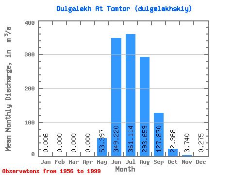
| Statistic | Jan | Feb | Mar | Apr | May | Jun | Jul | Aug | Sep | Oct | Nov | Dec | Annual |
|---|---|---|---|---|---|---|---|---|---|---|---|---|---|
| Mean | 0.01 | 0.00 | 0.00 | 0.00 | 53.40 | 349.22 | 361.11 | 293.66 | 127.87 | 22.37 | 3.74 | 0.28 | 100.97 |
| Standard Deviation | 0.04 | 0.00 | 0.00 | 0.00 | 42.68 | 185.85 | 174.49 | 145.17 | 66.54 | 8.70 | 2.17 | 0.36 | 32.62 |
| Min | 0.00 | 0.00 | 0.00 | 0.00 | 0.44 | 76.00 | 120.00 | 22.70 | 49.10 | 8.45 | 0.00 | 0.00 | 40.02 |
| Max | 0.24 | 0.00 | 0.00 | 0.00 | 217.00 | 874.00 | 772.00 | 636.00 | 342.00 | 40.50 | 9.79 | 1.70 | 178.50 |
| Coefficient of Variation | 5.71 | 0.80 | 0.53 | 0.48 | 0.49 | 0.52 | 0.39 | 0.58 | 1.30 | 0.32 |
 Return to R-Arctic Net Home Page