|
|
|||||||||||||||||
| Point ID: 6293 | Downloads | Plots | Site Data | Code: 3414 |
|
|
|||||||||||||||||
| Download | |
|---|---|
| Site Descriptor Information | Site Time Series Data |
| Link to all available data | |
| View: | Time Series | All |
| Units: | mm |
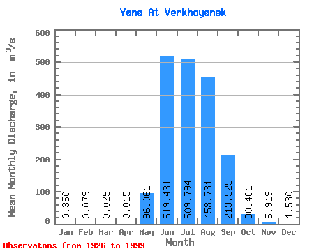
| Statistic | Jan | Feb | Mar | Apr | May | Jun | Jul | Aug | Sep | Oct | Nov | Dec | Annual |
|---|---|---|---|---|---|---|---|---|---|---|---|---|---|
| Mean | 0.35 | 0.08 | 0.03 | 0.01 | 96.06 | 519.43 | 509.79 | 453.73 | 213.53 | 30.40 | 5.92 | 1.53 | 154.69 |
| Standard Deviation | 0.36 | 0.14 | 0.07 | 0.05 | 86.80 | 280.84 | 244.32 | 217.23 | 124.38 | 13.55 | 2.84 | 1.01 | 48.26 |
| Min | 0.00 | 0.00 | 0.00 | 0.00 | 0.09 | 60.90 | 133.00 | 117.00 | 73.70 | 12.70 | 1.29 | 0.00 | 66.85 |
| Max | 1.72 | 0.72 | 0.42 | 0.29 | 391.00 | 1290.00 | 1140.00 | 919.00 | 720.00 | 86.40 | 13.20 | 4.46 | 309.96 |
| Coefficient of Variation | 1.03 | 1.73 | 2.89 | 3.14 | 0.90 | 0.54 | 0.48 | 0.48 | 0.58 | 0.45 | 0.48 | 0.66 | 0.31 |
 Return to R-Arctic Net Home Page