|
|
|||||||||||||||||
| Point ID: 6234 | Downloads | Plots | Site Data | Code: 3222 |
|
|
|||||||||||||||||
| Download | |
|---|---|
| Site Descriptor Information | Site Time Series Data |
| Link to all available data | |
| View: | Time Series | All |
| Units: | mm |
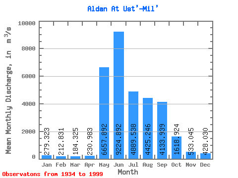
| Statistic | Jan | Feb | Mar | Apr | May | Jun | Jul | Aug | Sep | Oct | Nov | Dec | Annual |
|---|---|---|---|---|---|---|---|---|---|---|---|---|---|
| Mean | 279.32 | 212.83 | 184.32 | 230.98 | 6657.89 | 9224.89 | 4889.54 | 4425.25 | 4133.94 | 1618.92 | 533.04 | 428.03 | 2737.87 |
| Standard Deviation | 74.36 | 55.38 | 49.05 | 181.09 | 2490.30 | 2832.97 | 2087.17 | 1810.55 | 1613.02 | 596.62 | 145.75 | 123.91 | 466.08 |
| Min | 165.00 | 118.00 | 85.10 | 94.90 | 1680.00 | 4390.00 | 1760.00 | 1250.00 | 1500.00 | 717.00 | 294.00 | 217.00 | 1901.83 |
| Max | 503.00 | 375.00 | 350.00 | 1510.00 | 12100.00 | 17700.00 | 10100.00 | 8970.00 | 9360.00 | 2930.00 | 1080.00 | 811.00 | 3893.67 |
| Coefficient of Variation | 0.27 | 0.26 | 0.27 | 0.78 | 0.37 | 0.31 | 0.43 | 0.41 | 0.39 | 0.37 | 0.27 | 0.29 | 0.17 |
 Return to R-Arctic Net Home Page