|
|
|||||||||||||||||
| Point ID: 6233 | Downloads | Plots | Site Data | Code: 3220 |
|
|
|||||||||||||||||
| Download | |
|---|---|
| Site Descriptor Information | Site Time Series Data |
| Link to all available data | |
| View: | Time Series | All |
| Units: | mm |
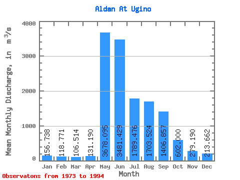
| Statistic | Jan | Feb | Mar | Apr | May | Jun | Jul | Aug | Sep | Oct | Nov | Dec | Annual |
|---|---|---|---|---|---|---|---|---|---|---|---|---|---|
| Mean | 156.74 | 118.77 | 106.51 | 131.19 | 3678.09 | 3481.43 | 1789.48 | 1703.52 | 1406.86 | 602.00 | 279.19 | 213.66 | 1138.95 |
| Standard Deviation | 60.72 | 43.67 | 39.91 | 61.07 | 965.43 | 1507.22 | 657.59 | 766.45 | 580.30 | 221.04 | 97.82 | 83.79 | 205.28 |
| Min | 55.50 | 47.30 | 44.70 | 48.00 | 1320.00 | 1390.00 | 771.00 | 554.00 | 546.00 | 313.00 | 115.00 | 95.90 | 680.08 |
| Max | 285.00 | 212.00 | 203.00 | 291.00 | 5870.00 | 6160.00 | 3090.00 | 3120.00 | 2870.00 | 1120.00 | 462.00 | 436.00 | 1538.42 |
| Coefficient of Variation | 0.39 | 0.37 | 0.38 | 0.47 | 0.26 | 0.43 | 0.37 | 0.45 | 0.41 | 0.37 | 0.35 | 0.39 | 0.18 |
 Return to R-Arctic Net Home Page