|
|
|||||||||||||||||
| Point ID: 6232 | Downloads | Plots | Site Data | Code: 3219 |
|
|
|||||||||||||||||
| Download | |
|---|---|
| Site Descriptor Information | Site Time Series Data |
| Link to all available data | |
| View: | Time Series | All |
| Units: | mm |
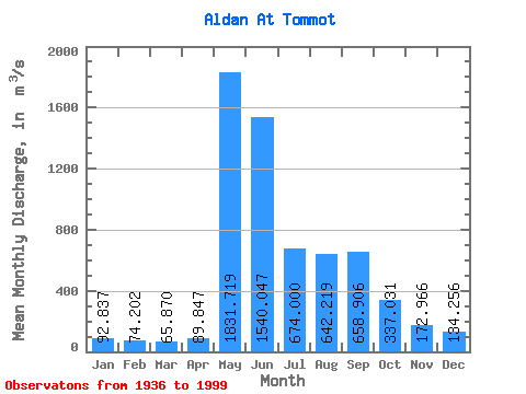
| Statistic | Jan | Feb | Mar | Apr | May | Jun | Jul | Aug | Sep | Oct | Nov | Dec | Annual |
|---|---|---|---|---|---|---|---|---|---|---|---|---|---|
| Mean | 92.84 | 74.20 | 65.87 | 89.85 | 1831.72 | 1540.05 | 674.00 | 642.22 | 658.91 | 337.03 | 172.97 | 134.26 | 526.16 |
| Standard Deviation | 31.06 | 23.67 | 22.00 | 64.04 | 531.24 | 690.03 | 330.64 | 284.16 | 271.42 | 122.27 | 51.85 | 48.37 | 102.05 |
| Min | 34.10 | 32.40 | 25.80 | 34.00 | 717.00 | 483.00 | 208.00 | 163.00 | 221.00 | 107.00 | 83.80 | 61.80 | 257.24 |
| Max | 179.00 | 144.00 | 135.00 | 426.00 | 3160.00 | 3750.00 | 2130.00 | 1360.00 | 1280.00 | 603.00 | 297.00 | 274.00 | 807.25 |
| Coefficient of Variation | 0.34 | 0.32 | 0.33 | 0.71 | 0.29 | 0.45 | 0.49 | 0.44 | 0.41 | 0.36 | 0.30 | 0.36 | 0.19 |
 Return to R-Arctic Net Home Page