|
|
|||||||||||||||||
| Point ID: 6226 | Downloads | Plots | Site Data | Code: 3207 |
|
|
|||||||||||||||||
| Download | |
|---|---|
| Site Descriptor Information | Site Time Series Data |
| Link to all available data | |
| View: | Time Series | All |
| Units: | mm |
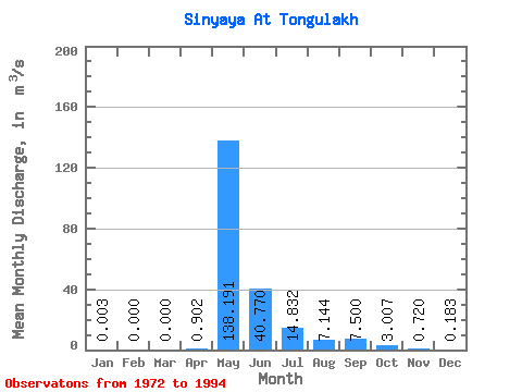
| Statistic | Jan | Feb | Mar | Apr | May | Jun | Jul | Aug | Sep | Oct | Nov | Dec | Annual |
|---|---|---|---|---|---|---|---|---|---|---|---|---|---|
| Mean | 0.00 | 0.00 | 0.00 | 0.90 | 138.19 | 40.77 | 14.83 | 7.14 | 7.50 | 3.01 | 0.72 | 0.18 | 17.77 |
| Standard Deviation | 0.01 | 0.00 | 0.00 | 4.06 | 133.16 | 31.30 | 19.52 | 15.07 | 11.37 | 3.93 | 1.58 | 0.58 | 12.58 |
| Min | 0.00 | 0.00 | 0.00 | 0.00 | 0.00 | 7.63 | 1.23 | 0.73 | 0.43 | 0.59 | 0.03 | 0.00 | 5.38 |
| Max | 0.04 | 0.00 | 0.00 | 19.50 | 650.00 | 132.00 | 74.50 | 73.20 | 49.40 | 16.90 | 7.61 | 2.81 | 57.84 |
| Coefficient of Variation | 2.91 | 4.50 | 0.96 | 0.77 | 1.32 | 2.11 | 1.52 | 1.31 | 2.19 | 3.15 | 0.71 |
 Return to R-Arctic Net Home Page