|
|
|||||||||||||||||
| Point ID: 6224 | Downloads | Plots | Site Data | Code: 3202 |
|
|
|||||||||||||||||
| Download | |
|---|---|
| Site Descriptor Information | Site Time Series Data |
| Link to all available data | |
| View: | Time Series | All |
| Units: | mm |
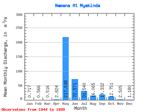
| Statistic | Jan | Feb | Mar | Apr | May | Jun | Jul | Aug | Sep | Oct | Nov | Dec | Annual |
|---|---|---|---|---|---|---|---|---|---|---|---|---|---|
| Mean | 0.72 | 0.57 | 0.52 | 2.82 | 217.54 | 72.57 | 31.54 | 16.07 | 19.33 | 12.75 | 2.50 | 1.18 | 31.87 |
| Standard Deviation | 0.33 | 0.32 | 0.33 | 5.76 | 125.54 | 59.09 | 45.02 | 18.54 | 32.67 | 20.27 | 1.31 | 0.56 | 17.14 |
| Min | 0.14 | 0.02 | 0.12 | 0.23 | 49.10 | 14.10 | 3.93 | 2.71 | 0.97 | 0.67 | 0.17 | 0.09 | 10.98 |
| Max | 1.54 | 1.68 | 1.58 | 29.10 | 677.00 | 358.00 | 233.00 | 105.00 | 239.00 | 131.00 | 7.70 | 2.70 | 109.42 |
| Coefficient of Variation | 0.46 | 0.57 | 0.64 | 2.04 | 0.58 | 0.81 | 1.43 | 1.15 | 1.69 | 1.59 | 0.53 | 0.47 | 0.54 |
 Return to R-Arctic Net Home Page