|
|
|||||||||||||||||
| Point ID: 6219 | Downloads | Plots | Site Data | Code: 3172 |
|
|
|||||||||||||||||
| Download | |
|---|---|
| Site Descriptor Information | Site Time Series Data |
| Link to all available data | |
| View: | Time Series | All |
| Units: | mm |
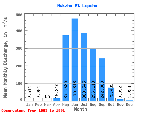
| Statistic | Jan | Feb | Mar | Apr | May | Jun | Jul | Aug | Sep | Oct | Nov | Dec | Annual |
|---|---|---|---|---|---|---|---|---|---|---|---|---|---|
| Mean | 0.61 | 0.08 | 15.31 | 374.63 | 470.82 | 388.55 | 296.12 | 242.01 | 75.48 | 9.09 | 1.95 | ||
| Standard Deviation | 0.50 | 0.08 | 29.53 | 202.33 | 356.90 | 158.56 | 156.79 | 105.51 | 41.03 | 4.56 | 1.09 | ||
| Min | 0.07 | 0.03 | 0.47 | 7.41 | 119.00 | 118.00 | 94.30 | 71.10 | 30.60 | 4.06 | 1.02 | ||
| Max | 1.29 | 0.14 | 75.20 | 628.00 | 1290.00 | 609.00 | 478.00 | 392.00 | 144.00 | 17.40 | 3.97 | ||
| Coefficient of Variation | 0.81 | 0.94 | 1.93 | 0.54 | 0.76 | 0.41 | 0.53 | 0.44 | 0.54 | 0.50 | 0.56 |
 Return to R-Arctic Net Home Page