|
|
|||||||||||||||||
| Point ID: 6203 | Downloads | Plots | Site Data | Code: 3150 |
|
|
|||||||||||||||||
| Download | |
|---|---|
| Site Descriptor Information | Site Time Series Data |
| Link to all available data | |
| View: | Time Series | All |
| Units: | mm |
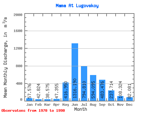
| Statistic | Jan | Feb | Mar | Apr | May | Jun | Jul | Aug | Sep | Oct | Nov | Dec | Annual |
|---|---|---|---|---|---|---|---|---|---|---|---|---|---|
| Mean | 57.58 | 42.82 | 38.58 | 47.35 | 416.95 | 1316.19 | 794.81 | 594.10 | 483.48 | 237.71 | 108.32 | 82.08 | 353.71 |
| Standard Deviation | 14.99 | 9.99 | 7.66 | 16.94 | 148.98 | 249.59 | 297.07 | 201.63 | 147.22 | 61.68 | 35.28 | 22.56 | 56.49 |
| Min | 33.40 | 24.60 | 27.50 | 30.00 | 220.00 | 1000.00 | 341.00 | 280.00 | 278.00 | 139.00 | 68.90 | 44.40 | 247.38 |
| Max | 105.00 | 59.10 | 55.50 | 103.00 | 733.00 | 1980.00 | 1350.00 | 1110.00 | 863.00 | 369.00 | 195.00 | 150.00 | 446.19 |
| Coefficient of Variation | 0.26 | 0.23 | 0.20 | 0.36 | 0.36 | 0.19 | 0.37 | 0.34 | 0.30 | 0.26 | 0.33 | 0.28 | 0.16 |
 Return to R-Arctic Net Home Page