|
|
|||||||||||||||||
| Point ID: 6189 | Downloads | Plots | Site Data | Code: 3127 |
|
|
|||||||||||||||||
| Download | |
|---|---|
| Site Descriptor Information | Site Time Series Data |
| Link to all available data | |
| View: | Time Series | All |
| Units: | mm |
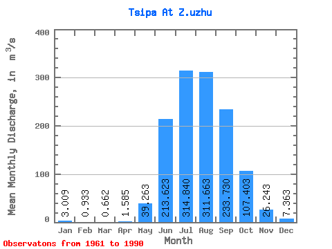
| Statistic | Jan | Feb | Mar | Apr | May | Jun | Jul | Aug | Sep | Oct | Nov | Dec | Annual |
|---|---|---|---|---|---|---|---|---|---|---|---|---|---|
| Mean | 3.01 | 0.93 | 0.66 | 1.58 | 39.26 | 213.62 | 314.84 | 311.66 | 233.73 | 107.40 | 26.24 | 7.36 | 105.03 |
| Standard Deviation | 3.36 | 1.16 | 1.02 | 1.97 | 25.24 | 94.51 | 145.12 | 193.03 | 129.58 | 68.43 | 17.13 | 4.37 | 42.27 |
| Min | 0.00 | 0.00 | 0.00 | 0.00 | 2.10 | 89.40 | 50.70 | 41.90 | 76.90 | 26.80 | 0.73 | 0.08 | 28.37 |
| Max | 15.70 | 5.49 | 5.67 | 10.60 | 127.00 | 438.00 | 563.00 | 788.00 | 577.00 | 362.00 | 90.90 | 19.30 | 198.89 |
| Coefficient of Variation | 1.12 | 1.24 | 1.54 | 1.24 | 0.64 | 0.44 | 0.46 | 0.62 | 0.55 | 0.64 | 0.65 | 0.59 | 0.40 |
 Return to R-Arctic Net Home Page