|
|
|||||||||||||||||
| Point ID: 6173 | Downloads | Plots | Site Data | Other Close Sites | Code: 3101 |
|
|
|||||||||||||||||
| Download | |
|---|---|
| Site Descriptor Information | Site Time Series Data |
| Link to all available data | |
| View: | Time Series | All |
| Units: | mm |
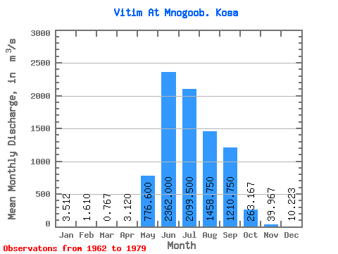
| Statistic | Jan | Feb | Mar | Apr | May | Jun | Jul | Aug | Sep | Oct | Nov | Dec | Annual |
|---|---|---|---|---|---|---|---|---|---|---|---|---|---|
| Mean | 3.51 | 1.61 | 0.77 | 3.12 | 776.60 | 2362.00 | 2099.50 | 1458.75 | 1210.75 | 263.17 | 39.97 | 10.22 | 639.08 |
| Standard Deviation | 1.39 | 1.23 | 0.64 | 1.47 | 232.27 | 1104.65 | 1191.67 | 782.05 | 595.51 | 70.44 | 13.13 | 5.75 | 61.33 |
| Min | 1.77 | 0.19 | 0.01 | 1.65 | 479.00 | 706.00 | 686.00 | 608.00 | 712.00 | 181.00 | 25.50 | 0.14 | 566.21 |
| Max | 5.46 | 3.41 | 1.62 | 5.46 | 995.00 | 3930.00 | 4660.00 | 3210.00 | 2580.00 | 374.00 | 57.70 | 15.20 | 733.56 |
| Coefficient of Variation | 0.40 | 0.76 | 0.84 | 0.47 | 0.30 | 0.47 | 0.57 | 0.54 | 0.49 | 0.27 | 0.33 | 0.56 | 0.10 |
| Other Close Sites | ||||||
|---|---|---|---|---|---|---|
| PointID | Latitude | Longitude | Drainage Area | Source | Name | |
| 6174 | "Vitim At Spitsino" | 56.22 | 1607210 | SHI | 743.00 | |
 Return to R-Arctic Net Home Page