|
|
|||||||||||||||||
| Point ID: 6163 | Downloads | Plots | Site Data | Code: 3083 |
|
|
|||||||||||||||||
| Download | |
|---|---|
| Site Descriptor Information | Site Time Series Data |
| Link to all available data | |
| View: | Time Series | All |
| Units: | mm |
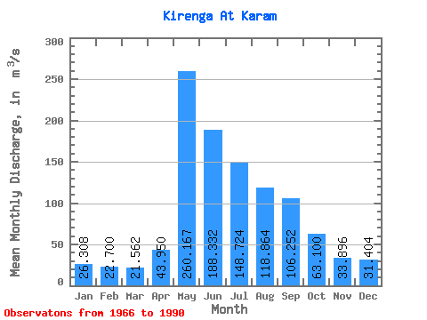
| Statistic | Jan | Feb | Mar | Apr | May | Jun | Jul | Aug | Sep | Oct | Nov | Dec | Annual |
|---|---|---|---|---|---|---|---|---|---|---|---|---|---|
| Mean | 26.31 | 22.70 | 21.56 | 43.95 | 260.17 | 188.33 | 148.72 | 118.86 | 106.25 | 63.10 | 33.90 | 31.40 | 89.09 |
| Standard Deviation | 6.51 | 6.35 | 6.72 | 28.16 | 62.19 | 63.02 | 100.76 | 71.79 | 52.16 | 26.16 | 10.01 | 8.42 | 21.47 |
| Min | 14.70 | 15.50 | 11.10 | 18.60 | 145.00 | 69.10 | 52.20 | 53.60 | 45.70 | 28.00 | 13.30 | 15.40 | 63.64 |
| Max | 41.40 | 42.70 | 38.10 | 134.00 | 377.00 | 340.00 | 572.00 | 335.00 | 252.00 | 123.00 | 48.20 | 47.70 | 153.03 |
| Coefficient of Variation | 0.25 | 0.28 | 0.31 | 0.64 | 0.24 | 0.34 | 0.68 | 0.60 | 0.49 | 0.41 | 0.29 | 0.27 | 0.24 |
 Return to R-Arctic Net Home Page