|
|
|||||||||||||||||
| Point ID: 6152 | Downloads | Plots | Site Data | Code: 3063 |
|
|
|||||||||||||||||
| Download | |
|---|---|
| Site Descriptor Information | Site Time Series Data |
| Link to all available data | |
| View: | Time Series | All |
| Units: | mm |
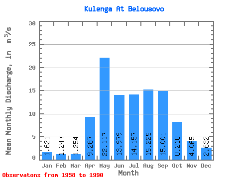
| Statistic | Jan | Feb | Mar | Apr | May | Jun | Jul | Aug | Sep | Oct | Nov | Dec | Annual |
|---|---|---|---|---|---|---|---|---|---|---|---|---|---|
| Mean | 1.62 | 1.25 | 1.25 | 9.29 | 22.12 | 13.98 | 14.16 | 15.22 | 15.00 | 8.22 | 4.07 | 2.63 | 9.10 |
| Standard Deviation | 1.16 | 0.96 | 0.94 | 9.53 | 12.59 | 13.08 | 9.53 | 12.29 | 12.76 | 5.20 | 2.62 | 1.79 | 3.69 |
| Min | 0.08 | 0.08 | 0.03 | 0.32 | 6.56 | 1.85 | 1.85 | 1.64 | 1.70 | 1.38 | 0.68 | 0.42 | 3.00 |
| Max | 5.16 | 4.10 | 3.75 | 37.50 | 53.30 | 56.30 | 34.30 | 52.40 | 64.90 | 19.50 | 10.40 | 7.21 | 17.98 |
| Coefficient of Variation | 0.71 | 0.77 | 0.75 | 1.03 | 0.57 | 0.94 | 0.67 | 0.81 | 0.85 | 0.63 | 0.64 | 0.68 | 0.41 |
 Return to R-Arctic Net Home Page