|
|
|||||||||||||||||
| Point ID: 6137 | Downloads | Plots | Site Data | Code: 3003 |
|
|
|||||||||||||||||
| Download | |
|---|---|
| Site Descriptor Information | Site Time Series Data |
| Link to all available data | |
| View: | Time Series | All |
| Units: | mm |
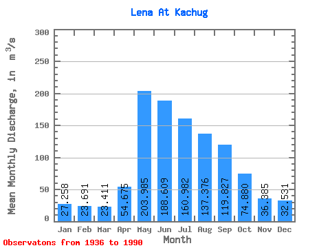
| Statistic | Jan | Feb | Mar | Apr | May | Jun | Jul | Aug | Sep | Oct | Nov | Dec | Annual |
|---|---|---|---|---|---|---|---|---|---|---|---|---|---|
| Mean | 27.26 | 23.69 | 23.41 | 54.67 | 203.99 | 188.61 | 160.98 | 137.38 | 119.83 | 74.88 | 36.38 | 32.53 | 90.47 |
| Standard Deviation | 8.19 | 7.08 | 6.83 | 31.44 | 65.03 | 71.15 | 87.75 | 70.84 | 62.56 | 30.75 | 13.91 | 10.88 | 22.81 |
| Min | 10.60 | 8.71 | 6.41 | 18.10 | 97.20 | 75.60 | 49.40 | 50.20 | 39.20 | 32.20 | 15.60 | 13.90 | 50.24 |
| Max | 46.70 | 43.10 | 43.00 | 158.00 | 385.00 | 421.00 | 526.00 | 333.00 | 351.00 | 161.00 | 81.30 | 63.40 | 151.47 |
| Coefficient of Variation | 0.30 | 0.30 | 0.29 | 0.57 | 0.32 | 0.38 | 0.55 | 0.52 | 0.52 | 0.41 | 0.38 | 0.34 | 0.25 |
 Return to R-Arctic Net Home Page