|
|
|||||||||||||||||
| Point ID: 5865 | Downloads | Plots | Site Data | Code: 1095 |
|
|
|||||||||||||||||
| Download | |
|---|---|
| Site Descriptor Information | Site Time Series Data |
| Link to all available data | |
| View: | Time Series | All |
| Units: | mm |
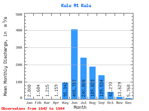
| Statistic | Jan | Feb | Mar | Apr | May | Jun | Jul | Aug | Sep | Oct | Nov | Dec | Annual |
|---|---|---|---|---|---|---|---|---|---|---|---|---|---|
| Mean | 2.81 | 1.68 | 1.22 | 1.16 | 95.34 | 405.76 | 240.81 | 189.82 | 139.53 | 42.27 | 13.63 | 5.77 | 94.98 |
| Standard Deviation | 1.47 | 0.88 | 0.64 | 0.75 | 79.01 | 199.21 | 89.52 | 77.97 | 69.61 | 16.47 | 4.92 | 2.51 | 21.35 |
| Min | 0.87 | 0.34 | 0.29 | 0.38 | 4.76 | 94.10 | 97.60 | 59.40 | 31.10 | 16.10 | 6.43 | 2.09 | 34.36 |
| Max | 7.45 | 5.45 | 3.88 | 4.35 | 325.00 | 1060.00 | 580.00 | 430.00 | 337.00 | 104.00 | 26.50 | 13.50 | 140.95 |
| Coefficient of Variation | 0.52 | 0.52 | 0.52 | 0.65 | 0.83 | 0.49 | 0.37 | 0.41 | 0.50 | 0.39 | 0.36 | 0.43 | 0.23 |
 Return to R-Arctic Net Home Page