|
|
|||||||||||||||||
| Point ID: 5812 | Downloads | Plots | Site Data | Code: 09CA003 |
|
|
|||||||||||||||||
| Download | |
|---|---|
| Site Descriptor Information | Site Time Series Data |
| Link to all available data | |
| View: | Time Series | All |
| Units: | mm |
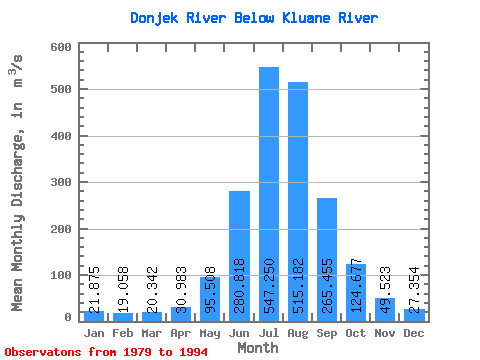
| Statistic | Jan | Feb | Mar | Apr | May | Jun | Jul | Aug | Sep | Oct | Nov | Dec | Annual |
|---|---|---|---|---|---|---|---|---|---|---|---|---|---|
| Mean | 21.88 | 19.06 | 20.34 | 30.98 | 95.51 | 280.82 | 547.25 | 515.18 | 265.45 | 124.68 | 49.52 | 27.35 | 167.02 |
| Standard Deviation | 5.53 | 4.46 | 6.30 | 14.42 | 32.88 | 55.11 | 83.38 | 102.75 | 83.87 | 46.10 | 16.22 | 8.25 | 26.61 |
| Min | 13.40 | 11.70 | 11.20 | 12.80 | 50.00 | 210.00 | 458.00 | 400.00 | 145.00 | 56.40 | 27.50 | 16.90 | 134.45 |
| Max | 31.50 | 26.10 | 32.80 | 58.00 | 180.00 | 364.00 | 689.00 | 747.00 | 407.00 | 190.00 | 73.70 | 41.90 | 219.57 |
| Coefficient of Variation | 0.25 | 0.23 | 0.31 | 0.47 | 0.34 | 0.20 | 0.15 | 0.20 | 0.32 | 0.37 | 0.33 | 0.30 | 0.16 |
 Return to R-Arctic Net Home Page