|
|
|||||||||||||||||
| Point ID: 5795 | Downloads | Plots | Site Data | Code: 09AE001 |
|
|
|||||||||||||||||
| Download | |
|---|---|
| Site Descriptor Information | Site Time Series Data |
| Link to all available data | |
| View: | Time Series | All |
| Units: | mm |
| Statistic | Jan | Feb | Mar | Apr | May | Jun | Jul | Aug | Sep | Oct | Nov | Dec | Annual |
|---|---|---|---|---|---|---|---|---|---|---|---|---|---|
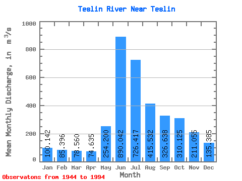
| Mean | 100.14 | 85.40 | 78.56 | 74.64 | 254.20 | 890.04 | 726.42 | 415.53 | 326.64 | 310.12 | 211.06 | 135.38 | 303.64 |
| Standard Deviation | 28.48 | 22.61 | 16.66 | 13.51 | 87.74 | 228.57 | 211.26 | 96.58 | 97.38 | 95.23 | 61.83 | 34.06 | 50.14 |
| Min | 44.50 | 41.80 | 43.50 | 48.70 | 94.60 | 394.00 | 319.00 | 191.00 | 158.00 | 123.00 | 87.60 | 49.00 | 179.10 |
| Max | 169.00 | 137.00 | 119.00 | 113.00 | 476.00 | 1420.00 | 1320.00 | 637.00 | 687.00 | 565.00 | 366.00 | 216.00 | 413.67 |
| Coefficient of Variation | 0.28 | 0.27 | 0.21 | 0.18 | 0.34 | 0.26 | 0.29 | 0.23 | 0.30 | 0.31 | 0.29 | 0.25 | 0.17 |
 Return to R-Arctic Net Home Page