|
|
|||||||||||||||||
| Point ID: 5577 | Downloads | Plots | Site Data | Code: 06AG001 |
|
|
|||||||||||||||||
| Download | |
|---|---|
| Site Descriptor Information | Site Time Series Data |
| Link to all available data | |
| View: | Time Series | All |
| Units: | mm |
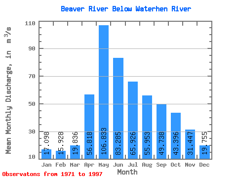
| Statistic | Jan | Feb | Mar | Apr | May | Jun | Jul | Aug | Sep | Oct | Nov | Dec | Annual |
|---|---|---|---|---|---|---|---|---|---|---|---|---|---|
| Mean | 17.10 | 15.93 | 19.84 | 56.82 | 106.83 | 83.28 | 65.93 | 55.95 | 49.74 | 43.40 | 31.45 | 19.75 | 45.84 |
| Standard Deviation | 11.69 | 10.99 | 12.11 | 28.03 | 104.97 | 79.79 | 55.62 | 43.36 | 35.94 | 30.15 | 28.04 | 15.00 | 32.89 |
| Min | 1.40 | 1.25 | 2.47 | 9.59 | 13.80 | 6.49 | 4.72 | 3.76 | 3.58 | 3.77 | 3.33 | 2.61 | 8.09 |
| Max | 44.70 | 44.30 | 55.70 | 152.00 | 549.00 | 387.00 | 207.00 | 147.00 | 145.00 | 125.00 | 141.00 | 72.40 | 161.58 |
| Coefficient of Variation | 0.68 | 0.69 | 0.61 | 0.49 | 0.98 | 0.96 | 0.84 | 0.78 | 0.72 | 0.69 | 0.89 | 0.76 | 0.72 |
 Return to R-Arctic Net Home Page