|
|
|||||||||||||||||
| Point ID: 3538 | Downloads | Plots | Site Data | Code: 06MA003 |
|
|
|||||||||||||||||
| Download | |
|---|---|
| Site Descriptor Information | Site Time Series Data |
| Link to all available data | |
| View: | Time Series | All |
| Units: | mm |
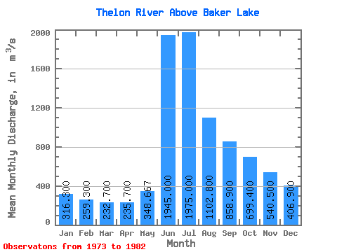
| Statistic | Jan | Feb | Mar | Apr | May | Jun | Jul | Aug | Sep | Oct | Nov | Dec | Annual |
|---|---|---|---|---|---|---|---|---|---|---|---|---|---|
| Mean | 316.30 | 259.30 | 232.70 | 235.70 | 348.67 | 1945.00 | 1975.00 | 1102.80 | 858.90 | 699.40 | 540.50 | 406.90 | 754.57 |
| Standard Deviation | 47.35 | 36.52 | 44.84 | 64.08 | 179.58 | 562.11 | 581.01 | 283.82 | 85.93 | 141.15 | 96.32 | 42.26 | 66.98 |
| Min | 254.00 | 203.00 | 171.00 | 146.00 | 135.00 | 1010.00 | 1370.00 | 701.00 | 733.00 | 451.00 | 363.00 | 342.00 | 656.42 |
| Max | 418.00 | 324.00 | 318.00 | 318.00 | 748.00 | 2510.00 | 3160.00 | 1780.00 | 1000.00 | 979.00 | 729.00 | 483.00 | 828.25 |
| Coefficient of Variation | 0.15 | 0.14 | 0.19 | 0.27 | 0.52 | 0.29 | 0.29 | 0.26 | 0.10 | 0.20 | 0.18 | 0.10 | 0.09 |
 Return to R-Arctic Net Home Page