|
|
|||||||||||||||||
| Point ID: 3530 | Downloads | Plots | Site Data | Code: 06JC002 |
|
|
|||||||||||||||||
| Download | |
|---|---|
| Site Descriptor Information | Site Time Series Data |
| Link to all available data | |
| View: | Time Series | All |
| Units: | mm |
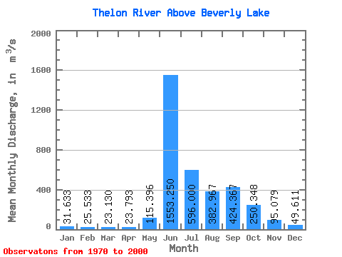
| Statistic | Jan | Feb | Mar | Apr | May | Jun | Jul | Aug | Sep | Oct | Nov | Dec | Annual |
|---|---|---|---|---|---|---|---|---|---|---|---|---|---|
| Mean | 31.63 | 25.53 | 23.13 | 23.79 | 115.40 | 1553.25 | 596.00 | 382.97 | 424.37 | 250.35 | 95.08 | 49.61 | 297.24 |
| Standard Deviation | 13.06 | 10.87 | 10.29 | 11.07 | 143.15 | 845.25 | 210.26 | 149.54 | 198.57 | 111.36 | 39.87 | 19.54 | 105.33 |
| Min | 18.80 | 14.90 | 11.10 | 10.40 | 14.90 | 416.00 | 199.00 | 178.00 | 191.00 | 61.10 | 34.50 | 25.40 | 145.28 |
| Max | 63.50 | 51.80 | 44.30 | 43.90 | 658.00 | 3760.00 | 1040.00 | 749.00 | 894.00 | 453.00 | 193.00 | 104.00 | 479.34 |
| Coefficient of Variation | 0.41 | 0.43 | 0.45 | 0.47 | 1.24 | 0.54 | 0.35 | 0.39 | 0.47 | 0.45 | 0.42 | 0.39 | 0.35 |
 Return to R-Arctic Net Home Page