|
|
|||||||||||||||||
| Point ID: 3135 | Downloads | Plots | Site Data | Code: 06GD001 |
|
|
|||||||||||||||||
| Download | |
|---|---|
| Site Descriptor Information | Site Time Series Data |
| Link to all available data | |
| View: | Time Series | All |
| Units: | mm |
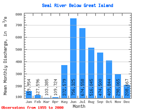
| Statistic | Jan | Feb | Mar | Apr | May | Jun | Jul | Aug | Sep | Oct | Nov | Dec | Annual |
|---|---|---|---|---|---|---|---|---|---|---|---|---|---|
| Mean | 159.95 | 127.60 | 103.39 | 109.72 | 372.58 | 756.33 | 674.56 | 516.04 | 474.50 | 409.84 | 298.06 | 208.67 | 350.32 |
| Standard Deviation | 45.29 | 31.22 | 22.42 | 41.80 | 223.73 | 286.07 | 229.45 | 181.35 | 268.89 | 217.78 | 139.01 | 74.33 | 81.08 |
| Min | 65.10 | 62.30 | 59.50 | 64.40 | 92.80 | 364.00 | 332.00 | 228.00 | 185.00 | 147.00 | 113.00 | 85.00 | 222.32 |
| Max | 253.00 | 187.00 | 151.00 | 298.00 | 1080.00 | 1610.00 | 1280.00 | 1030.00 | 1520.00 | 966.00 | 647.00 | 391.00 | 583.40 |
| Coefficient of Variation | 0.28 | 0.24 | 0.22 | 0.38 | 0.60 | 0.38 | 0.34 | 0.35 | 0.57 | 0.53 | 0.47 | 0.36 | 0.23 |
 Return to R-Arctic Net Home Page