|
|
|||||||||||||||||
| Point ID: 3120 | Downloads | Plots | Site Data | Code: 06EA006 |
|
|
|||||||||||||||||
| Download | |
|---|---|
| Site Descriptor Information | Site Time Series Data |
| Link to all available data | |
| View: | Time Series | All |
| Units: | mm |
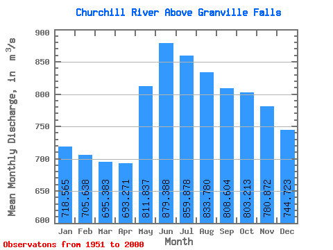
| Statistic | Jan | Feb | Mar | Apr | May | Jun | Jul | Aug | Sep | Oct | Nov | Dec | Annual |
|---|---|---|---|---|---|---|---|---|---|---|---|---|---|
| Mean | 718.57 | 705.64 | 695.38 | 693.27 | 811.84 | 879.39 | 859.88 | 833.78 | 808.60 | 803.21 | 780.87 | 744.72 | 779.84 |
| Standard Deviation | 149.51 | 135.06 | 134.09 | 135.08 | 148.76 | 201.42 | 245.43 | 257.56 | 253.00 | 255.01 | 243.44 | 193.25 | 159.94 |
| Min | 354.00 | 335.00 | 331.00 | 347.00 | 533.00 | 467.00 | 426.00 | 461.00 | 407.00 | 376.00 | 370.00 | 376.00 | 468.33 |
| Max | 1220.00 | 1040.00 | 954.00 | 949.00 | 1130.00 | 1340.00 | 1480.00 | 1520.00 | 1400.00 | 1380.00 | 1710.00 | 1570.00 | 1117.92 |
| Coefficient of Variation | 0.21 | 0.19 | 0.19 | 0.20 | 0.18 | 0.23 | 0.28 | 0.31 | 0.31 | 0.32 | 0.31 | 0.26 | 0.20 |
 Return to R-Arctic Net Home Page