|
|
|||||||||||||||||
| Point ID: 8972 | Downloads | Plots | Site Data | Code: 71086 |
|
|
|||||||||||||||||
| Download | |
|---|---|
| Site Descriptor Information | Site Time Series Data |
| Link to all available data | |
| View: | Time Series | All |
| Units: | m3/s |
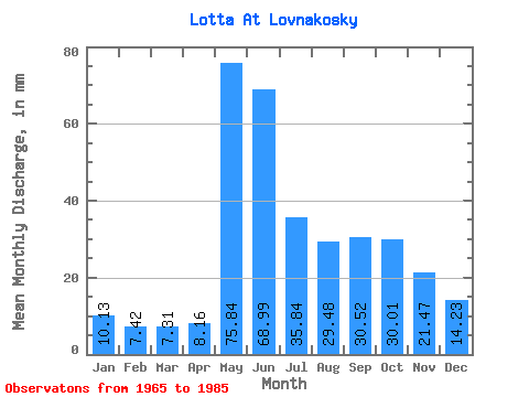
| Statistic | Jan | Feb | Mar | Apr | May | Jun | Jul | Aug | Sep | Oct | Nov | Dec | Annual |
|---|---|---|---|---|---|---|---|---|---|---|---|---|---|
| Mean | 10.13 | 7.48 | 7.31 | 8.16 | 75.83 | 68.99 | 35.83 | 29.48 | 30.52 | 30.01 | 21.47 | 14.23 | 338.00 |
| Standard Deviation | 1.53 | 1.11 | 1.06 | 3.82 | 32.25 | 25.74 | 16.20 | 13.82 | 13.66 | 9.61 | 13.20 | 3.48 | 65.99 |
| Min | 7.45 | 5.44 | 5.86 | 5.05 | 24.83 | 31.13 | 18.68 | 10.88 | 10.59 | 11.71 | 10.13 | 9.64 | 240.76 |
| Max | 13.60 | 9.86 | 9.46 | 23.52 | 128.88 | 121.30 | 86.31 | 72.12 | 68.09 | 52.67 | 73.81 | 24.59 | 481.35 |
| Coefficient of Variation | 0.15 | 0.15 | 0.14 | 0.47 | 0.42 | 0.37 | 0.45 | 0.47 | 0.45 | 0.32 | 0.61 | 0.24 | 0.20 |
 Return to R-Arctic Net Home Page