|
|
|||||||||||||||||
| Point ID: 804 | Downloads | Plots | Site Data | Code: 07NB001 |
|
|
|||||||||||||||||
| Download | |
|---|---|
| Site Descriptor Information | Site Time Series Data |
| Link to all available data | |
| View: | Time Series | All |
| Units: | m3/s |
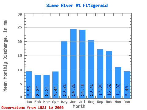
| Statistic | Jan | Feb | Mar | Apr | May | Jun | Jul | Aug | Sep | Oct | Nov | Dec | Annual |
|---|---|---|---|---|---|---|---|---|---|---|---|---|---|
| Mean | 9.54 | 8.29 | 8.24 | 9.44 | 20.26 | 24.28 | 24.16 | 20.42 | 17.30 | 16.52 | 11.02 | 9.49 | 177.80 |
| Standard Deviation | 2.21 | 2.62 | 3.15 | 3.81 | 3.62 | 5.15 | 5.77 | 5.15 | 3.67 | 3.15 | 2.78 | 2.28 | 27.74 |
| Min | 5.57 | 2.32 | 2.40 | 2.69 | 12.82 | 13.39 | 14.01 | 13.30 | 11.16 | 11.89 | 7.36 | 5.92 | 134.54 |
| Max | 14.14 | 13.53 | 17.46 | 22.16 | 32.79 | 33.88 | 35.04 | 32.44 | 25.36 | 25.41 | 21.56 | 18.96 | 255.62 |
| Coefficient of Variation | 0.23 | 0.32 | 0.38 | 0.40 | 0.18 | 0.21 | 0.24 | 0.25 | 0.21 | 0.19 | 0.25 | 0.24 | 0.16 |
 Return to R-Arctic Net Home Page