|
|
|||||||||||||||||
| Point ID: 7579 | Downloads | Plots | Site Data | Code: 71044 |
|
|
|||||||||||||||||
| Download | |
|---|---|
| Site Descriptor Information | Site Time Series Data |
| Link to all available data | |
| View: | Time Series | All |
| Units: | m3/s |
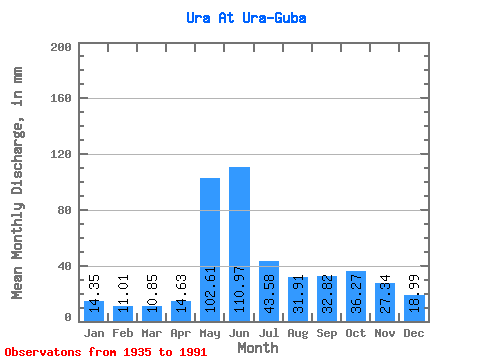
| Statistic | Jan | Feb | Mar | Apr | May | Jun | Jul | Aug | Sep | Oct | Nov | Dec | Annual |
|---|---|---|---|---|---|---|---|---|---|---|---|---|---|
| Mean | 14.35 | 11.11 | 10.85 | 14.63 | 102.59 | 110.97 | 43.58 | 31.91 | 32.82 | 36.26 | 27.34 | 18.99 | 450.12 |
| Standard Deviation | 3.70 | 2.72 | 2.31 | 8.56 | 46.77 | 47.27 | 20.36 | 16.78 | 14.91 | 12.19 | 11.09 | 5.12 | 92.35 |
| Min | 6.83 | 6.22 | 6.83 | 7.24 | 25.10 | 29.48 | 9.92 | 6.04 | 8.66 | 13.52 | 7.45 | 8.69 | 209.19 |
| Max | 23.16 | 17.37 | 16.33 | 47.77 | 215.55 | 224.64 | 113.68 | 94.25 | 96.31 | 66.95 | 72.93 | 37.81 | 678.21 |
| Coefficient of Variation | 0.26 | 0.24 | 0.21 | 0.58 | 0.46 | 0.43 | 0.47 | 0.53 | 0.45 | 0.34 | 0.41 | 0.27 | 0.20 |
 Return to R-Arctic Net Home Page