|
|
|||||||||||||||||
| Point ID: 7566 | Downloads | Plots | Site Data | Code: 70842 |
|
|
|||||||||||||||||
| Download | |
|---|---|
| Site Descriptor Information | Site Time Series Data |
| Link to all available data | |
| View: | Time Series | All |
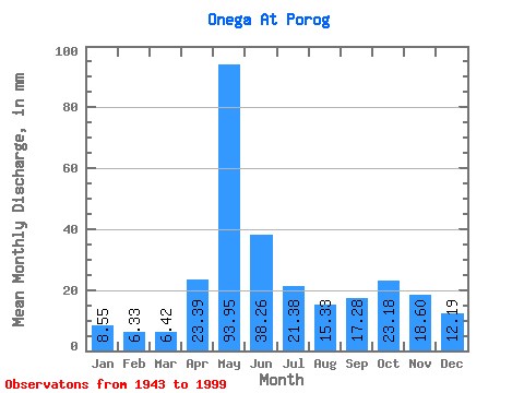
| Units: | m3/s |
| Statistic | Jan | Feb | Mar | Apr | May | Jun | Jul | Aug | Sep | Oct | Nov | Dec | Annual |
|---|---|---|---|---|---|---|---|---|---|---|---|---|---|
| Mean | 8.55 | 6.38 | 6.42 | 23.39 | 93.94 | 38.26 | 21.38 | 15.33 | 17.29 | 23.17 | 18.60 | 12.19 | 278.82 |
| Standard Deviation | 2.42 | 1.50 | 1.54 | 19.72 | 25.25 | 12.71 | 7.43 | 6.71 | 10.88 | 12.33 | 9.92 | 5.92 | 55.79 |
| Min | 4.95 | 3.83 | 4.12 | 4.55 | 38.03 | 16.94 | 9.57 | 7.74 | 6.51 | 7.26 | 5.63 | 5.53 | 175.13 |
| Max | 14.09 | 9.59 | 12.12 | 77.34 | 149.04 | 76.78 | 38.51 | 42.74 | 55.38 | 54.33 | 41.18 | 32.55 | 418.06 |
| Coefficient of Variation | 0.28 | 0.23 | 0.24 | 0.84 | 0.27 | 0.33 | 0.35 | 0.44 | 0.63 | 0.53 | 0.53 | 0.48 | 0.20 |
 Return to R-Arctic Net Home Page