|
|
|||||||||||||||||
| Point ID: 7440 | Downloads | Plots | Site Data | Code: 70328 |
|
|
|||||||||||||||||
| Download | |
|---|---|
| Site Descriptor Information | Site Time Series Data |
| Link to all available data | |
| View: | Time Series | All |
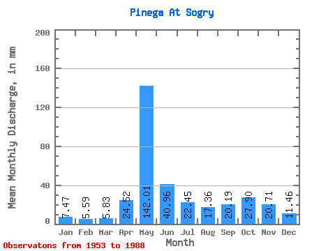
| Units: | m3/s |
| Statistic | Jan | Feb | Mar | Apr | May | Jun | Jul | Aug | Sep | Oct | Nov | Dec | Annual |
|---|---|---|---|---|---|---|---|---|---|---|---|---|---|
| Mean | 7.47 | 5.64 | 5.83 | 24.52 | 141.99 | 40.96 | 22.44 | 17.36 | 20.19 | 27.90 | 20.71 | 11.46 | 344.26 |
| Standard Deviation | 1.84 | 1.09 | 0.84 | 33.51 | 43.03 | 18.59 | 13.51 | 13.57 | 9.68 | 11.39 | 9.51 | 5.76 | 59.42 |
| Min | 4.70 | 3.65 | 4.43 | 5.40 | 54.42 | 14.12 | 6.53 | 3.72 | 5.91 | 8.67 | 7.84 | 5.81 | 185.49 |
| Max | 12.79 | 8.05 | 7.42 | 165.32 | 242.91 | 85.57 | 62.74 | 67.64 | 44.36 | 57.51 | 46.52 | 28.67 | 426.62 |
| Coefficient of Variation | 0.25 | 0.19 | 0.14 | 1.37 | 0.30 | 0.45 | 0.60 | 0.78 | 0.48 | 0.41 | 0.46 | 0.50 | 0.17 |
 Return to R-Arctic Net Home Page