|
|
|||||||||||||||||
| Point ID: 7372 | Downloads | Plots | Site Data | Code: 70155 |
|
|
|||||||||||||||||
| Download | |
|---|---|
| Site Descriptor Information | Site Time Series Data |
| Link to all available data | |
| View: | Time Series | All |
| Units: | m3/s |
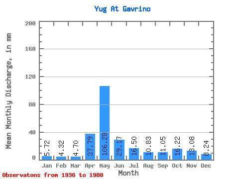
| Statistic | Jan | Feb | Mar | Apr | May | Jun | Jul | Aug | Sep | Oct | Nov | Dec | Annual |
|---|---|---|---|---|---|---|---|---|---|---|---|---|---|
| Mean | 5.72 | 4.36 | 4.70 | 37.79 | 106.27 | 29.18 | 16.50 | 10.83 | 11.04 | 16.21 | 13.07 | 8.24 | 262.57 |
| Standard Deviation | 1.71 | 0.97 | 0.81 | 22.69 | 44.80 | 16.77 | 9.71 | 7.00 | 10.68 | 12.14 | 8.36 | 3.69 | 62.07 |
| Min | 2.31 | 2.52 | 3.30 | 5.72 | 26.32 | 7.67 | 5.15 | 4.50 | 4.18 | 5.55 | 4.86 | 3.38 | 127.87 |
| Max | 12.31 | 7.71 | 7.25 | 97.57 | 209.31 | 75.23 | 42.17 | 34.48 | 74.19 | 78.49 | 48.71 | 23.78 | 480.68 |
| Coefficient of Variation | 0.30 | 0.22 | 0.17 | 0.60 | 0.42 | 0.57 | 0.59 | 0.65 | 0.97 | 0.75 | 0.64 | 0.45 | 0.24 |
 Return to R-Arctic Net Home Page