|
|
|||||||||||||||||
| Point ID: 7221 | Downloads | Plots | Site Data | Code: 12320 |
|
|
|||||||||||||||||
| Download | |
|---|---|
| Site Descriptor Information | Site Time Series Data |
| Link to all available data | |
| View: | Time Series | All |
| Units: | m3/s |
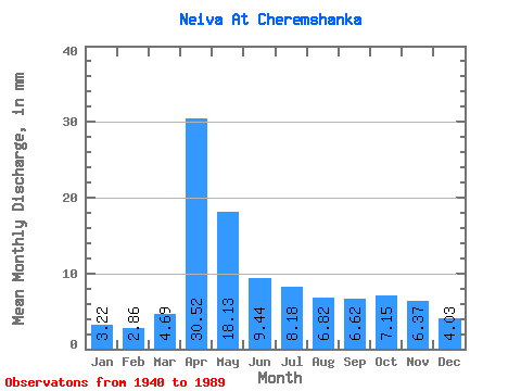
| Statistic | Jan | Feb | Mar | Apr | May | Jun | Jul | Aug | Sep | Oct | Nov | Dec | Annual |
|---|---|---|---|---|---|---|---|---|---|---|---|---|---|
| Mean | 3.22 | 2.88 | 4.69 | 30.52 | 18.12 | 9.44 | 8.18 | 6.82 | 6.62 | 7.14 | 6.37 | 4.03 | 109.69 |
| Standard Deviation | 2.15 | 2.31 | 3.15 | 18.08 | 12.50 | 5.49 | 5.25 | 8.55 | 6.61 | 6.22 | 5.00 | 3.06 | 50.12 |
| Min | 0.30 | 0.00 | 0.02 | 5.75 | 4.19 | 2.33 | 1.40 | 1.14 | 1.42 | 0.96 | 0.72 | 0.56 | 44.60 |
| Max | 11.00 | 13.90 | 18.57 | 82.78 | 52.84 | 23.41 | 24.19 | 60.47 | 41.11 | 25.92 | 24.25 | 17.71 | 280.08 |
| Coefficient of Variation | 0.67 | 0.80 | 0.67 | 0.59 | 0.69 | 0.58 | 0.64 | 1.25 | 1.00 | 0.87 | 0.79 | 0.76 | 0.46 |
 Return to R-Arctic Net Home Page