|
|
|||||||||||||||||
| Point ID: 7094 | Downloads | Plots | Site Data | Code: 11526 |
|
|
|||||||||||||||||
| Download | |
|---|---|
| Site Descriptor Information | Site Time Series Data |
| Link to all available data | |
| View: | Time Series | All |
| Units: | m3/s |
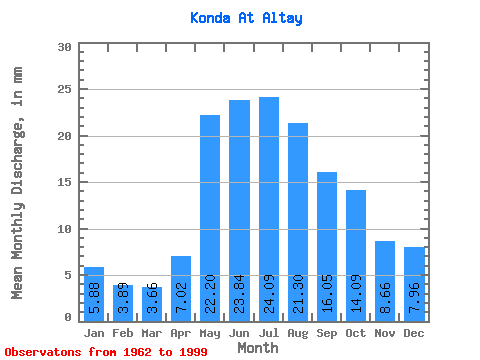
| Statistic | Jan | Feb | Mar | Apr | May | Jun | Jul | Aug | Sep | Oct | Nov | Dec | Annual |
|---|---|---|---|---|---|---|---|---|---|---|---|---|---|
| Mean | 5.88 | 3.93 | 3.66 | 7.02 | 22.20 | 23.84 | 24.08 | 21.29 | 16.05 | 14.09 | 8.66 | 7.96 | 157.39 |
| Standard Deviation | 3.59 | 1.92 | 1.09 | 3.42 | 4.60 | 5.68 | 7.45 | 8.58 | 8.13 | 7.88 | 5.03 | 4.53 | 45.93 |
| Min | 2.38 | 1.89 | 2.12 | 2.63 | 14.21 | 10.54 | 6.52 | 4.96 | 4.38 | 4.37 | 0.83 | 2.86 | 71.55 |
| Max | 17.88 | 12.84 | 8.31 | 19.95 | 31.74 | 37.29 | 37.28 | 35.06 | 32.53 | 30.61 | 19.72 | 17.88 | 267.56 |
| Coefficient of Variation | 0.61 | 0.49 | 0.30 | 0.49 | 0.21 | 0.24 | 0.31 | 0.40 | 0.51 | 0.56 | 0.58 | 0.57 | 0.29 |
 Return to R-Arctic Net Home Page