|
|
|||||||||||||||||
| Point ID: 7049 | Downloads | Plots | Site Data | Code: 11398 |
|
|
|||||||||||||||||
| Download | |
|---|---|
| Site Descriptor Information | Site Time Series Data |
| Link to all available data | |
| View: | Time Series | All |
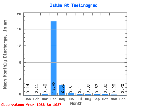
| Units: | m3/s |
| Statistic | Jan | Feb | Mar | Apr | May | Jun | Jul | Aug | Sep | Oct | Nov | Dec | Annual |
|---|---|---|---|---|---|---|---|---|---|---|---|---|---|
| Mean | 0.14 | 0.12 | 0.48 | 17.88 | 2.52 | 0.61 | 0.41 | 0.39 | 0.32 | 0.32 | 0.28 | 0.20 | 23.77 |
| Standard Deviation | 0.21 | 0.12 | 1.04 | 18.65 | 2.34 | 0.56 | 0.48 | 0.51 | 0.43 | 0.41 | 0.37 | 0.26 | 16.45 |
| Min | 0.00 | 0.00 | 0.00 | 0.18 | 0.05 | 0.01 | 0.00 | 0.01 | 0.01 | 0.01 | 0.01 | 0.01 | 3.02 |
| Max | 1.06 | 0.50 | 4.16 | 84.77 | 8.94 | 1.91 | 2.02 | 2.13 | 2.05 | 1.99 | 1.82 | 1.25 | 62.42 |
| Coefficient of Variation | 1.43 | 1.02 | 2.16 | 1.04 | 0.93 | 0.91 | 1.19 | 1.31 | 1.35 | 1.27 | 1.31 | 1.35 | 0.69 |
 Return to R-Arctic Net Home Page