|
|
|||||||||||||||||
| Point ID: 6904 | Downloads | Plots | Site Data | Code: 10565 |
|
|
|||||||||||||||||
| Download | |
|---|---|
| Site Descriptor Information | Site Time Series Data |
| Link to all available data | |
| View: | Time Series | All |
| Units: | m3/s |
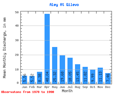
| Statistic | Jan | Feb | Mar | Apr | May | Jun | Jul | Aug | Sep | Oct | Nov | Dec | Annual |
|---|---|---|---|---|---|---|---|---|---|---|---|---|---|
| Mean | 5.56 | 5.57 | 8.38 | 48.03 | 25.31 | 19.68 | 18.05 | 13.45 | 11.82 | 9.99 | 11.13 | 7.46 | 194.51 |
| Standard Deviation | 1.67 | 1.44 | 6.79 | 26.68 | 18.76 | 7.18 | 6.90 | 4.65 | 5.08 | 5.84 | 7.75 | 5.89 | 49.62 |
| Min | 2.87 | 3.32 | 3.15 | 2.00 | 6.71 | 8.59 | 8.53 | 6.88 | 5.23 | 5.71 | 4.72 | 3.23 | 108.19 |
| Max | 8.10 | 7.54 | 24.14 | 91.63 | 59.02 | 28.07 | 32.15 | 20.04 | 19.23 | 23.28 | 23.61 | 22.77 | 268.59 |
| Coefficient of Variation | 0.30 | 0.26 | 0.81 | 0.56 | 0.74 | 0.36 | 0.38 | 0.35 | 0.43 | 0.58 | 0.70 | 0.79 | 0.26 |
 Return to R-Arctic Net Home Page