|
|
|||||||||||||||||
| Point ID: 6614 | Downloads | Plots | Site Data | Code: 9389 |
|
|
|||||||||||||||||
| Download | |
|---|---|
| Site Descriptor Information | Site Time Series Data |
| Link to all available data | |
| View: | Time Series | All |
| Units: | m3/s |
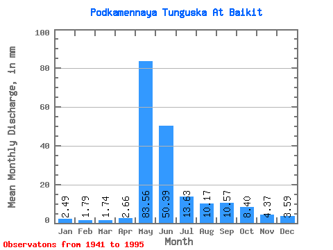
| Statistic | Jan | Feb | Mar | Apr | May | Jun | Jul | Aug | Sep | Oct | Nov | Dec | Annual |
|---|---|---|---|---|---|---|---|---|---|---|---|---|---|
| Mean | 2.49 | 1.80 | 1.74 | 2.66 | 83.55 | 50.39 | 13.63 | 10.17 | 10.57 | 8.40 | 4.37 | 3.59 | 193.42 |
| Standard Deviation | 0.94 | 0.75 | 0.76 | 3.13 | 18.52 | 28.71 | 4.93 | 5.01 | 5.00 | 4.62 | 1.75 | 1.52 | 41.63 |
| Min | 0.96 | 0.45 | 0.25 | 0.30 | 46.49 | 15.03 | 6.57 | 4.14 | 4.68 | 2.86 | 1.89 | 1.23 | 122.87 |
| Max | 5.76 | 4.43 | 4.03 | 22.82 | 118.07 | 162.04 | 27.45 | 33.85 | 26.57 | 23.07 | 11.53 | 8.71 | 313.60 |
| Coefficient of Variation | 0.38 | 0.42 | 0.43 | 1.18 | 0.22 | 0.57 | 0.36 | 0.49 | 0.47 | 0.55 | 0.40 | 0.42 | 0.21 |
 Return to R-Arctic Net Home Page