|
|
|||||||||||||||||
| Point ID: 6544 | Downloads | Plots | Site Data | Code: 9092 |
|
|
|||||||||||||||||
| Download | |
|---|---|
| Site Descriptor Information | Site Time Series Data |
| Link to all available data | |
| View: | Time Series | All |
| Units: | m3/s |
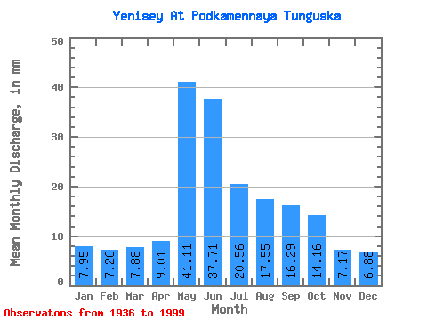
| Statistic | Jan | Feb | Mar | Apr | May | Jun | Jul | Aug | Sep | Oct | Nov | Dec | Annual |
|---|---|---|---|---|---|---|---|---|---|---|---|---|---|
| Mean | 7.95 | 7.33 | 7.88 | 9.01 | 41.11 | 37.71 | 20.56 | 17.55 | 16.29 | 14.16 | 7.17 | 6.88 | 193.10 |
| Standard Deviation | 2.17 | 2.48 | 3.15 | 4.03 | 7.75 | 10.41 | 4.81 | 4.55 | 3.21 | 2.01 | 2.08 | 1.80 | 16.70 |
| Min | 4.14 | 3.40 | 3.48 | 3.21 | 25.41 | 19.29 | 14.26 | 1.49 | 1.90 | 9.04 | 3.65 | 4.17 | 154.92 |
| Max | 11.85 | 11.73 | 13.56 | 23.71 | 59.34 | 75.70 | 33.78 | 26.02 | 22.53 | 19.78 | 13.17 | 10.77 | 226.61 |
| Coefficient of Variation | 0.27 | 0.34 | 0.40 | 0.45 | 0.19 | 0.28 | 0.23 | 0.26 | 0.20 | 0.14 | 0.29 | 0.26 | 0.09 |
 Return to R-Arctic Net Home Page