|
|
|||||||||||||||||
| Point ID: 6543 | Downloads | Plots | Site Data | Code: 9053 |
|
|
|||||||||||||||||
| Download | |
|---|---|
| Site Descriptor Information | Site Time Series Data |
| Link to all available data | |
| View: | Time Series | All |
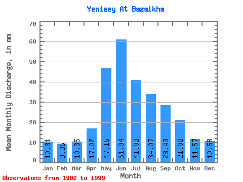
| Units: | m3/s |
| Statistic | Jan | Feb | Mar | Apr | May | Jun | Jul | Aug | Sep | Oct | Nov | Dec | Annual |
|---|---|---|---|---|---|---|---|---|---|---|---|---|---|
| Mean | 10.30 | 9.44 | 10.35 | 17.02 | 47.15 | 61.03 | 41.03 | 34.06 | 28.43 | 21.08 | 11.57 | 10.58 | 301.37 |
| Standard Deviation | 7.85 | 8.24 | 9.70 | 8.14 | 18.08 | 29.25 | 13.96 | 8.64 | 6.59 | 4.44 | 5.39 | 7.51 | 39.84 |
| Min | 3.41 | 2.89 | 2.87 | 5.00 | 22.41 | 22.55 | 22.41 | 16.51 | 12.96 | 9.46 | 4.25 | 3.83 | 208.48 |
| Max | 26.33 | 28.87 | 37.49 | 37.58 | 89.27 | 149.47 | 83.91 | 56.15 | 46.91 | 39.72 | 27.91 | 27.58 | 418.65 |
| Coefficient of Variation | 0.76 | 0.87 | 0.94 | 0.48 | 0.38 | 0.48 | 0.34 | 0.25 | 0.23 | 0.21 | 0.47 | 0.71 | 0.13 |
 Return to R-Arctic Net Home Page